
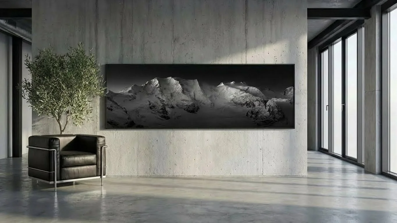
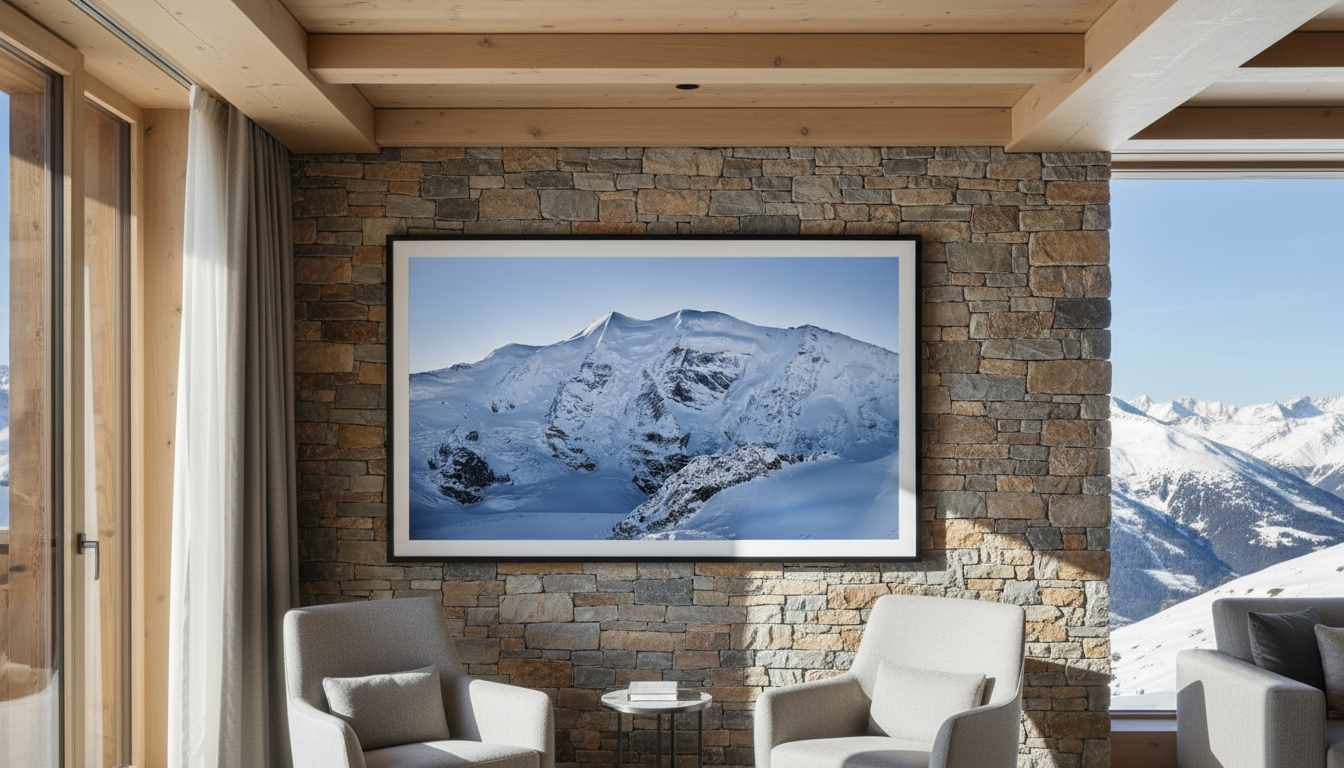
PIZ PALÜ
Bernina Range · Engadin · Graubünden
3'900 m · 12'795 ft
Swiss · Italian Border
The Mountain
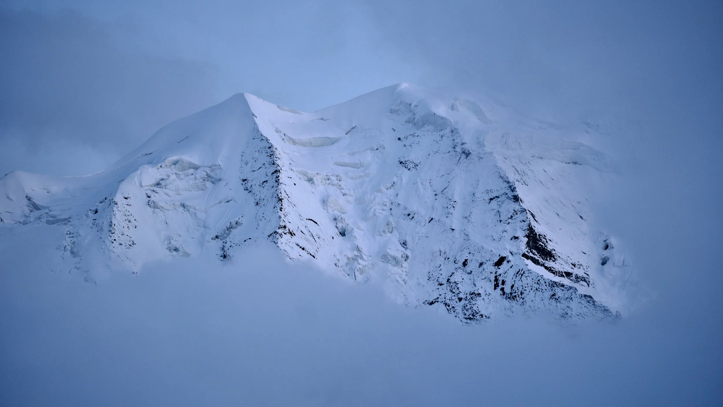
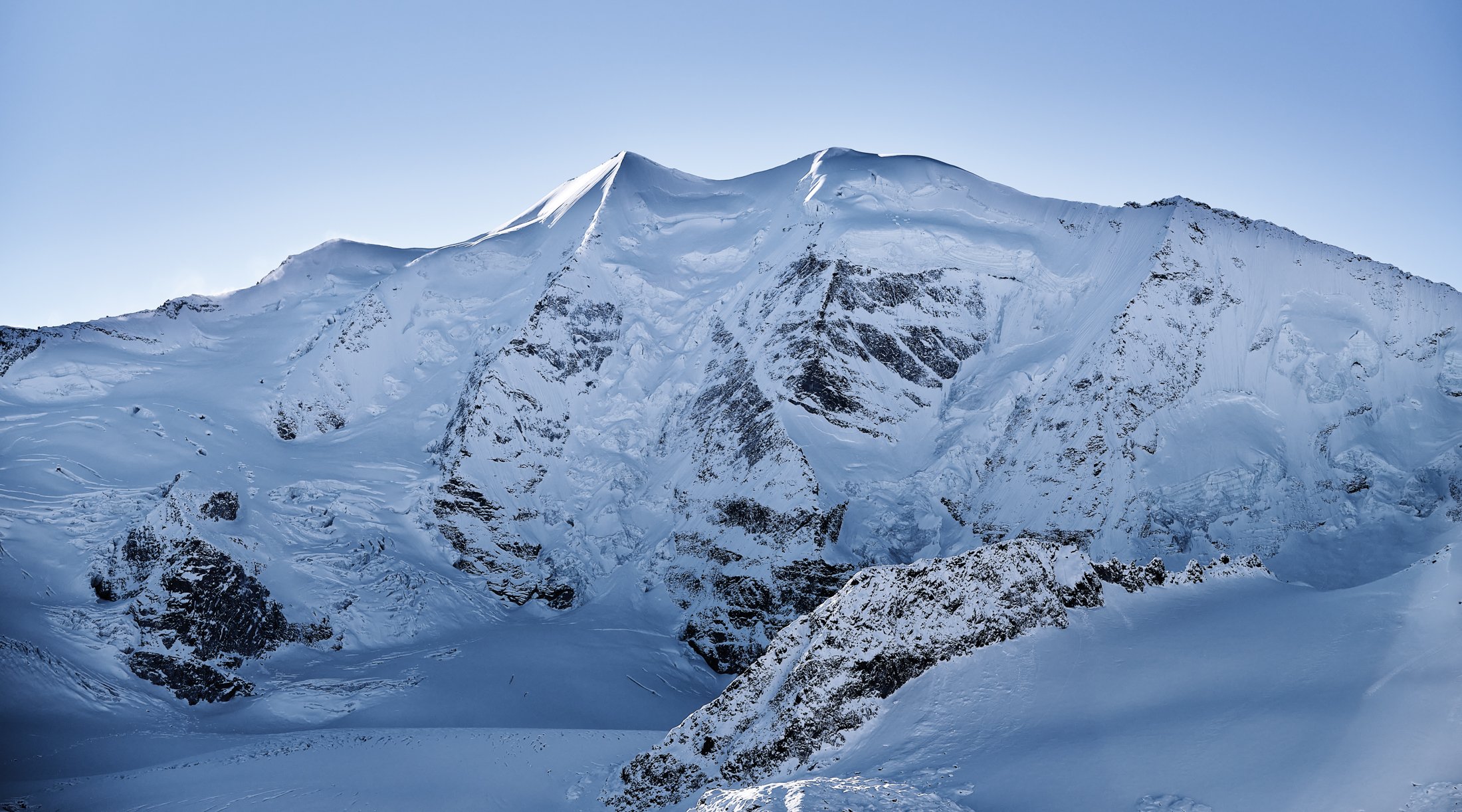
Three summits joined by curving ridges. Three hanging glaciers held between them. Of all the peaks in the Bernina Range, Piz Palü is the one that resembles a human work, symmetrical, sculptural, almost designed. From Diavolezza its north face fills the southern horizon like a single architectural gesture in ice and granite. The light that crosses it has been watched, walked beneath, and photographed for nearly two centuries. Climbers, painters, philosophers, filmmakers, each generation has returned to the same horizon and seen it differently. The mountain holds its proportions across every season, and every season changes everything else. To photograph it is to enter a conversation that began long before the camera arrived.


Inquire about a work from this peak
Pricing, availability, and installation guidance are shared in private correspondence. Each inquiry is answered personally by the artist's atelier.
A Mountain of Three Summits
Where the peak sits
The Bernina Range is the highest sub-range of the eastern Alps and the only part of the Eastern Alps to push above 4'000 metres, in Piz Bernina (4'049 m). Piz Palü is its second-highest summit, standing at 3'900 metres on the watershed between the Engadin and the Italian Valposchiavo. From the south the peak looks down on the Val Poschiavo and the long descent into Tirano. From the north, where it is best known, it stands above the Val Morteratsch and the Val Bernina, framed by the Diavolezza ridge and the Pers Glacier basin.
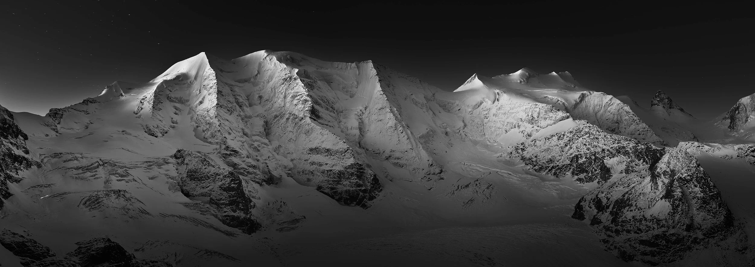
The peak has three distinct summits running east to west. The eastern summit, Piz Palü Ost, is the highest at 3'900 m. The central summit reaches 3'882 m, the western summit, sometimes named Spinas, 3'823 m. Connecting ridges curve between them, and the whole massif reads from a distance as a single composed architectural form. The most-photographed vantage is the Diavolezza cable car station, which delivers visitors at 2'978 metres on the opposite ridge of the basin and gives a clean, level view across the upper Pers Glacier to the entire north face. This is the geography that has shaped how the peak has been seen for nearly two centuries.
The signature of three summits
Few alpine peaks present so legibly. Many are masses of rock and ice that take days of approach to read clearly. Piz Palü is the opposite: a single composition that holds its proportions whether you see it from a station ridge in fresh snow, from the Bernina Express train passing the southern flank, or from a helicopter pulling level with its crest. Three summits, three hanging glaciers between them, two ridges descending in mirrored curves. Architects sometimes describe it as the mountain that looks designed.
The north face holds snow and ice through almost the entire year. Between the summits, the hanging glaciers calve serac fall onto the upper basin of the Pers Glacier at irregular intervals, sometimes audible across the Diavolezza ridge. In late spring and early summer the entire face catches first light for a window of less than an hour around dawn before the sun moves south, producing a brief gold-on-blue moment that is the foundation of much fine art work made of the peak.
Climbers and photographers refer to the central pillar between the middle and east summits as the Bumiller Pillar, named after the climbers Caspar and Otto Bumiller and their guide Hans Grass. It is one of the most recognisable ice-and-rock features in the eastern Alps and remains a benchmark alpine mixed climb today.
Walking under the north face: a brief history
The central summit, 3'882 metres, was first climbed on 12 August 1835 by Oswald Heer, a Swiss naturalist, palaeobotanist, and professor of botany at the University of Zurich. Heer ascended with the guide Johann Madutz of Glarus and a second guide whose name appears variably in different alpine club registers. The east summit, the highest point of the massif at 3'900 metres, was first reached later, in 1866, by Peter Jenny of Pontresina. The west summit fell soon after.
The full traverse of the three summits, from west to east via the connecting ridges, was first completed in September 1887 by the German polar and alpine explorer Paul Güssfeldt with guides Hans Grass and Caspar Capat. Güssfeldt described the climb in his 1886 collection In den Hochalpen and in subsequent essays. The traverse remains one of the great classic ridge enchainments in the Alps, comparable in standing to the Biancograt of Piz Bernina.
By the late nineteenth century the peak had become a fixture of Victorian alpinism. Leslie Stephen, the British critic and alpinist who became one of the founders of mountaineering literature, mentioned Bernina ascents in The Playground of Europe (1871). The records of the Swiss Alpine Club document a steady accumulation of new routes between the 1880s and the First World War. The peak's silhouette became part of the visual canon of Engadin alpinism and remains so today.
Painters, philosophers, and the white hell
The Bernina massif, with Piz Palü as one of its three principal subjects alongside Piz Bernina and Piz Roseg, holds a substantial place in the alpine canon. Its presence in painting, philosophy, and cinema is unusually dense for a single peak.
The painter most closely associated with this landscape is Giovanni Segantini (1858 to 1899). Segantini lived and worked in the Engadin from 1894 until his death and produced his late masterwork, the Alpine Triptych, Vita, Natura, Morte, in the high pastures within sight of the Bernina range. The triptych is now installed at the Segantini Museum in St. Moritz and remains one of the founding works of Symbolist alpine painting. Segantini died of peritonitis on 28 September 1899 on the Schafberg above Pontresina, on the easel of the central panel Natura. From his vantage that morning the Bernina massif filled the southern horizon. The British alpine painter Edward Theodore Compton (1849 to 1921) produced an extensive body of paintings and watercolours of the same range, including direct works of Piz Palü, Piz Bernina, and the Morteratsch valley, now held in private collections and Swiss alpine archives.
The peak also frames a chapter of European philosophy. Friedrich Nietzsche spent seven summers at Sils Maria, in the Upper Engadin, between 1881 and 1888. Substantial parts of Also sprach Zarathustra were written in that landscape, framed to the south by the Bernina massif. The Nietzsche-Stein near Surlej marks the spot where the idea of eternal recurrence reportedly came to him in August 1881. The horizon of those works is the horizon of Piz Palü, Piz Bernina, and Piz Corvatsch. Hermann Hesse travelled in the same region in the 1920s and described it in correspondence and journals.
Cinema arrived in 1929 with the silent film Die weiße Hölle vom Piz Palü (The White Hell of Piz Palü), directed by Arnold Fanck and co-directed by G. W. Pabst, starring Leni Riefenstahl, Gustav Diessl, and Ernst Petersen. The film is a foundational work of the German Bergfilm genre, shot largely on location on Piz Palü itself, and is considered one of the most accomplished silent mountain films of the era. It established the peak in early twentieth-century popular culture as the archetypal alpine north face. Fanck made a sound remake in 1935. Both versions exist in restored form. The 1929 film remains the single most cited cultural reference to Piz Palü in non-specialist sources.
The glaciers below
Piz Palü sits at the head of two of the most-studied glaciers in Switzerland. To the immediate north-east lies the Pers Glacier. To the north, the much larger Morteratsch Glacier flows down the long Val Morteratsch toward the Bernina Pass road and the railway corridor. Until 2015 the two were a single ice system, with the Pers entering the Morteratsch from the east as its largest tributary.
According to GLAMOS (Glacier Monitoring Switzerland), the Morteratsch has retreated approximately 2'900 metres since the end of the Little Ice Age in 1850, with the rate accelerating sharply since the year 2000. The Pers Glacier separated from the Morteratsch in 2015, an event that GLAMOS records as a defining moment in the recent retreat history of the Bernina massif. The visible signature of these changes is the year-marker boards along the Gletscherweg Morteratsch, the interpretive trail from the Morteratsch railway station to the current terminus.
Piz Palü is one of the principal subjects of glaciers.today, the long-term documentary project launched in 2023 on solar-powered 45-megapixel cameras at Diavolezza. The cameras photograph the Piz Palü north face, the Pers Glacier basin, and the upper Morteratsch every thirty minutes, twenty-four hours a day. The archive, freely accessible online and now exceeding 30'000 high-resolution images, is used operationally by Swiss Alpine Rescue (SAR) for mission planning and is integrated into research at GLAMOS and ETH Zürich. This makes Piz Palü the most thoroughly documented peak in the Alps in real time, and the documentation itself is part of the work.
Why we keep returning
A peak of this density rewards return. The light of the dawn window changes year to year. The ice between the summits calves and rebuilds. The Pers basin opens and closes with the seasons. After a winter of little snow the rock retreats and the geometry hardens. After a winter of heavy snow the entire face simplifies into a single white form. The peak photographs differently every season, every year, sometimes every day.
To photograph Piz Palü is to enter a conversation that began long before the camera arrived. Heer in 1835. Compton in the 1880s. Segantini on the Schafberg in 1899. Riefenstahl on the north face in 1929. Nietzsche under the same horizon in 1881, walking back to his summer rooms in Sils Maria. Each generation has returned to the same place and seen something different. A wall hanging in a private collection or a hotel lobby connects to that lineage. The work belongs to a peak that has been watched closely by enough people, for long enough, that the fact of being looked at is part of what the peak now is.
Questions, briefly answered
-
Piz Palü stands at 3'900 metres above sea level. The east summit at 3'900 m is the highest point of the three-summit massif. The central summit reaches 3'882 m, the west summit 3'823 m.
-
Piz Palü sits on the Swiss-Italian border in the Bernina Range, within the Engadin region of Graubünden canton. It is best viewed from the Diavolezza station at 2'978 metres above Pontresina. Coordinates: 46°22′44″ N, 9°57′36″ E.
-
The central summit was first climbed on 12 August 1835 by Swiss naturalist Oswald Heer with the guide Johann Madutz of Glarus. The east summit, at 3'900 m the highest point, was first reached in 1866 by Peter Jenny of Pontresina. The full three-summit traverse was completed in 1887 by Paul Güssfeldt with guides Hans Grass and Caspar Capat.
-
Piz Palü is unmistakable for its three glaciated summits joined by curving ridges, with hanging glaciers held between them on the north face. The geometry is unusually symmetrical, almost sculptural, and the face is documented continuously by glaciers.today, the solar-powered real-time archive at Diavolezza.
-
Limited edition fine art works of Piz Palü by Swiss photographer Jürg Kaufmann are available directly through the artist's catalogue at juergkaufmann.com. A work from this peak is installed at the Grace La Margna in St. Moritz.
Inquire about a work from this peak
Pricing, availability, and installation guidance are shared in private correspondence. Each inquiry is answered personally by the artist's atelier.

Hinschauen. Entscheiden. Dranbleiben.
glaciers.today is a long-term documentation project by Swiss mountain photographer Jürg Kaufmann. Two high-resolution cameras installed at Diavolezza, 3'092 m, photograph the Piz Palü north face, the Pers Glacier, and the upper Morteratsch Glacier every 30 minutes, 24 hours a day, since July 2023. The live archive is freely accessible online.